Location & Access
The QV – Yellow (”QV”) property is located in the west-central part of the Yukon, approximately 85 km south of Dawson City and 375 km northwest of Whitehorse. The Property is accessible by helicopter from Dawson City, and the Henderson airstrip located 6.5 km to the northeast provides small fixed-wing plane access. The Henderson airstrip is also road accessible from Dawson City allowing for a convenient staging area for servicing the property.
Size
1,003 claims covering 19,670 hectares
Work to Date
Soil sampling, LiDAR, Airborne DIGEM geophysics, Property-scale structural geology interpretation
Target (Mineralization)
Orogenic gold deposits.
Qualified Person
Terry Brace, P.Geo. and Vice President of Exploration for the Company is a “qualified person” as defined under National Instrument 43-101 – Standards of Disclosure of Mineral Projects and has reviewed and approved the content of this project summary.
Overview
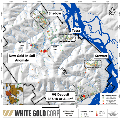
In 2023 a soil geochemistry survey identified a new 1 km long gold-in-soil anomaly in the Chris Creek area located approximately 9 km northwest of the VG deposit (see Company News Release dated February 22, 2024). The soil anomaly generally strikes east-west and is approximately 150 m in width. Ten (10) samples from the anomaly returned greater than 50 ppb Au in the range of 51.1 to 327 ppb Au. Geochemically, the anomaly also has associated anomalous tellurium and low arsenic-in-soil values. This geochemical signature is comparable to the VG and Golden Saddle deposits suggesting a similar style of mineralization. The strike length of the soil anomaly is generally comparable to that of the VG deposit anomaly and remains open along strike to the east and west.
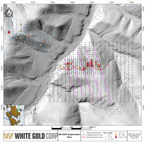
Planned exploration work in 2024 will focus on detailing and drill-testing the soil anomaly. Early season work will include additional infill and expansion soil geochemistry sampling and ground VLF-EM surveying. The infill soil samples will provide higher sample density and resolution of the anomaly, and 2D inversions of the VLF-EM data is expected to provide a reliable dip on the associated controlling geological structure. Four diamond drill holes totalling approximately 1200 m are planned to test the target along its strike length, with final hole locations to be selected based on results of the ground surveys.


